Drone Roof Inspection & Thermal Imaging Planning
A Foot Survey Misses Too Much of a Big Lubbock Roof
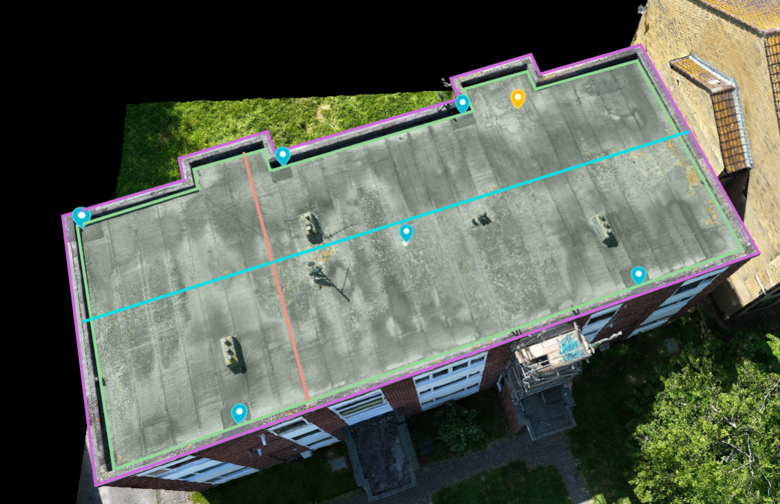
Walk a hundred-thousand-square-foot warehouse roof out by the Lubbock Business Park or along the rail-served industrial blocks off East Loop at a time. The far corners go unchecked, low spots that pond hidden water never make the report, and every step lands on a membrane already baked brittle by 260-plus days of high-plains sun. We do not start that way anymore. We launch a drone, hold it at a fixed altitude, and photograph the entire roof field in a fraction of the time, capturing every drain basin, lap seam, curb, and flashing in high resolution without putting a single bootprint on a roof whose condition nobody has confirmed yet.
Keeping people off an unknown roof is not a minor convenience. Foot traffic is itself a damage source on aged membranes and on ballasted or coated systems, where one careless step crushes insulation or fractures a coating. It is also a fall-protection exposure on a roof we have not assessed. Flying the first pass lets us learn the roof, mark the soft spots and structural concerns, and plan any follow-up walk so a crew only goes where it is both safe and genuinely necessary.
The Infrared Pass Is the Whole Point
The single most valuable thing an aerial inspection produces is the thermal scan. A radiometric infrared camera reads surface temperature, and on a roof that is decisive because wet insulation and dry insulation behave nothing alike. Saturated board carries far more thermal mass than dry board, so after a sunny Lubbock day it holds the absorbed heat long into the evening while the dry field around it sheds heat and cools. During that post-sunset cool-down window, the waterlogged zones glow warm against the cooler dry roof and the camera maps their exact footprint. On these wide flat roofs a thermal pass routinely exposes saturation creeping out from a failed seam or a tired drain detail long before anything shows on the surface or drips into the building.
That moisture map drives the only decision that matters. It separates a targeted repair that cuts out a few defined wet bays from a full tear-off because water has spread across a third of the deck. Without the map you are guessing, and guessing on a commercial roof costs you in both directions: you either over-buy a replacement you did not need or you patch around a problem that keeps quietly growing under the new work. We verify the thermal findings with a small number of core cuts at flagged locations, so the map is confirmed rather than merely inferred, and then we scope to what the roof actually needs.
Flying Legally Around Preston Smith
Commercial drone work is regulated, and we operate squarely inside the rules. Every flight runs under the FAA's Part 107 framework, which governs how and where a small commercial aircraft may operate. That matters acutely in Lubbock, because Class C controlled airspace wraps around Preston Smith International Airport northwest of downtown, and a large share of the city's industrial and commercial roofs sit inside or right up against it. Operating there can require authorization through the FAA's LAANC system before a flight is legal, and we secure that clearance rather than hoping no one notices. We also keep the aircraft within visual line of sight, watch the gusty conditions that the open Llano Estacado throws at us, and stand down when wind or weather would compromise either safety or image quality. A blurry, wind-jostled thermal frame is worse than no frame at all.
Documentation an Adjuster Will Actually Accept
Lubbock takes hail, hard. The city sits in the heart of the Texas High Plains hail corridor, where spring and early-summer supercells routinely roll off the Caprock and drop stones that pit metal, bruise membranes, and trigger commercial property claims across whole districts at once. After a storm we produce documentation built for the claims process: GPS-tagged imagery tied to specific roof locations, hail-impact density mapped across the field, wind-related displacement and lifted-edge patterns, and condition records for rooftop equipment and flashings. Because the report is organized to the format adjusters expect, it drops straight into a claim file and can be reviewed remotely, which compresses the timeline and cuts the back-and-forth over what the damage actually was.
The same imagery earns its keep when no storm is involved. Before we write a reroofing proposal, an aerial survey pins down accurate roof-area measurements and a complete inventory of penetrations, curbs, and drains. Designing from measured reality instead of a rough field sketch slashes the change orders and requests-for-information that otherwise surface mid-project once the crew uncovers something the estimate missed.
When Flying a Roof Is Worth It
Aerial inspection earns its keep on large flat commercial roofs: logistics and distribution buildings, retail centers, office parks, hospital and university campus complexes, anything where a foot survey is slow, incomplete, and hard on the membrane. On a small or steeply pitched roof a person can inspect quickly and thoroughly and the drone adds little. As a working rule, for any commercial roof above roughly ten thousand square feet that needs a true condition assessment, flying it is the faster and more complete approach. When a property does not need it, we will tell you so plainly.
Drone Roof Inspection Questions
How is a drone inspection better than someone walking the roof?
It covers the entire surface systematically from a consistent altitude and builds a full photographic record without the foot traffic that wears on aging membranes and creates fall exposure. On large Lubbock roofs a walkover takes hours and still misses corners and low spots, and the infrared moisture survey simply is not practical on foot at that scale.
Can thermal imaging really show where water is trapped in the roof?
Yes, under the right conditions. Flown during the cool-down period after sunset, the camera reads wet insulation as warm zones because saturated board holds the day's heat longer than the dry field around it. We confirm the flagged areas with a few core cuts so the moisture map is verified before it drives a repair-versus-replace decision.
Are you allowed to fly near the airport?
We operate under FAA Part 107, and because Class C airspace surrounds Preston Smith International we obtain LAANC authorization wherever it is required before flying those sites. We also keep the aircraft in visual line of sight and stand down in the high winds and weather the open plains regularly deliver.
Can I use the footage for an insurance claim?
That is one of its primary uses. We produce GPS-tagged imagery documenting hail-impact density, wind displacement, and equipment and flashing condition, organized to the format adjusters expect so it goes directly into a claim file and can be reviewed remotely. For contested claims we can provide a supporting statement built on the documentation.
What kinds of roofs are worth flying?
Large flat commercial roofs benefit most: warehouses, distribution and industrial buildings, retail centers, and multi-building campuses. Small or steeply pitched roofs are usually faster to inspect on foot. For commercial roofs above roughly ten thousand square feet needing a full condition assessment, the drone is the more efficient and thorough option.
Next Step
Send the building address, roof age if known, leak photos or condition photos, roof access notes, tenant limits, and the decision timeline. We will shape the roof walk around roof evidence, access limits, weather exposure, and budget timing and return a practical scope tied to what can be verified.